Forest
Thailand Environment Statistics 2020
112
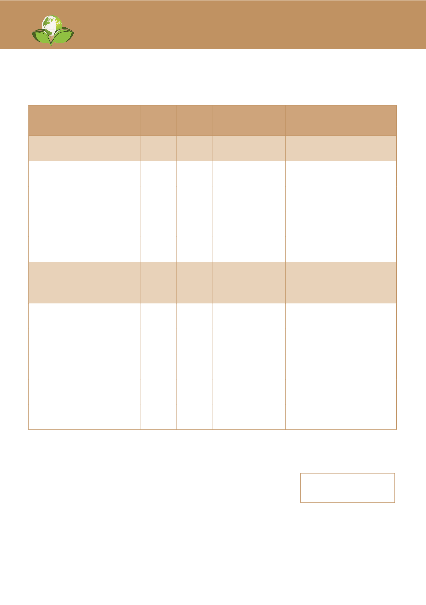
ตารางที่
5.6 พื้
นที่
ป่
าที่
ถู
กไฟไหม้
พ.ศ. 2558 - 2562
Table 5.6 Forest Fire Area: 2015 – 2019
หน่
วย (Unit): ไร่
(Rais)
ภาค
2558
(2015)
2559
(2016)
2560
(2017)
2561
(2018)
2562
(2019)
Region
เขตพื้
นที่
กรมป่
าไม้
43,165 62,584 37,714 17,556 63,901 Royal Forest Department Area
เหนือ
24,803 48,755 31,313 14,896 49,353 Northern
ตะวั
นออกเฉี
ยงเหนื
อ 7,281
8,751 4,629
2,117
6,732
Northeastern
กลาง
9,275 3,214 1,734
439
3,191 Central
ใต้
1,806 1,865
38
104
4,625 Southern
เขตพื้
นที่
กรมอุ
ทยาน
แห่
งชาติสั
ตว์
ป่
าและ
พั
นธุ์
พืช
60,453 125,896 75,419 55,766 151,772 Department of National Parks,
Wildlife and Plant Conservation
Area
เหนือ
35,862 70,603 60,774 43,437 102,469 Northern
ตะวั
นออกเฉี
ยงเหนื
อ 14,853 26,709 10,648 9,699 23,407 Northeastern
กลาง
4,515 6,326 2,357
1,244
6,556 Central
ตะวั
นออก
2,622 4,756 1,011
388
1,416 Eastern
ใต้
2,602 17,502 629
998 17,925 Southern
ที่
มา: กรมป่าไม้ และกรมอุ
ทยานแห่
งชาติสั
ตว์
ป่
าและพั
นธุ์
พืช กระทรวงทรั
พยากรธรรมชาติและสิ่
งแวดล้อม
Source: Royal Forest Department and Department of National Parks, Wildlife and Plant Conservation,
Ministry of Natural Resources and Environment
1 ไร่
= 1/625 ตารางกิโลเมตร
1 Rai = 1/625 Sq.km.


